📸 Aerial Photography & Videography
Drone photography and videography is one of the most popular and versatile services we offer. Here’s a deeper dive into the types of services, industries served, deliverables, and value-adds
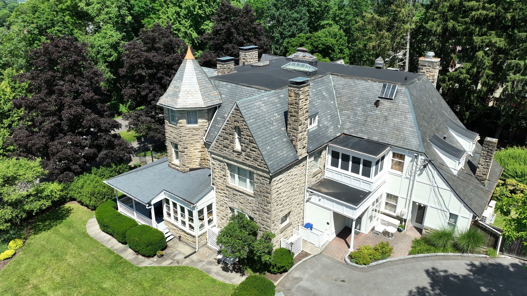
Drone Photos & Videos
✓ Real estate marketing
✓ Weddings & events
✓ Tourism promotion
✓ Film & TV production
🎯 Key Industries Served
- Real Estate
- Residential & commercial property listings
- Aerial views of lots, land, and large estates
- Neighborhood and amenity overviews
- Construction updates for developers
- Film & Media
- Cinematic drone shots for movies, TV, music videos
- Commercials and branded content
- Sports and live events
- Events
- Weddings, concerts, festivals
- Corporate gatherings or promotional events
- Religious or cultural ceremonies
- Tourism & Hospitality
- Resort and hotel showcases
- Destination marketing for travel agencies
- Scenic flyovers of landmarks, parks, or cities
- Marketing & Advertising
- Social media content for brands
- Product launches or business showcases
- Storytelling through immersive visual content
🛠️ Typical Deliverables
- High-resolution aerial photos (up to 4K or 8K)
- Stabilized 4K+ aerial videos
- Edited highlight reels or sizzle videos
- Vertical videos optimized for Instagram/TikTok
- Raw footage for agency editing
- Interactive 360° photos or virtual tours
💡 Value-Adds and Differentiators
- Cinematography expertise: Using flight paths, lighting, and gimbal motion to create dynamic and dramatic shots.
- Post-production services: Color grading, sound design, transitions, and motion graphics.
- Live streaming capabilities: For events or media coverage in real time.
- Night flying and low-light shots: With proper waivers and lighting equipment.
- FPV drones: First-person-view drones for high-adrenaline shots like fast-moving chase scenes or tight indoor fly-throughs.
📋 Legal & Logistical Considerations
- FAA Part 107 certification (in the U.S.)
- Flight waivers for restricted areas (e.g., near airports or at night)
- Liability insurance
- Client release forms and NDAs
- Location scouting and safety assessments
🔧 Equipment Used
- Professional drones designed and built in the USA by DVaerialCAM
- FPV drones for dynamic motion
- Gimbal stabilization for smooth video
- Filters (ND, polarizers) for cinematic looks
- High-end editing software
🛰️ Drone Mapping & Surveying
We use drones equipped with high-resolution cameras, LiDAR, or multispectral sensors to capture aerial data, which is then processed into maps, models, and measurements. This process is often faster, safer, and more cost-effective than traditional surveying.
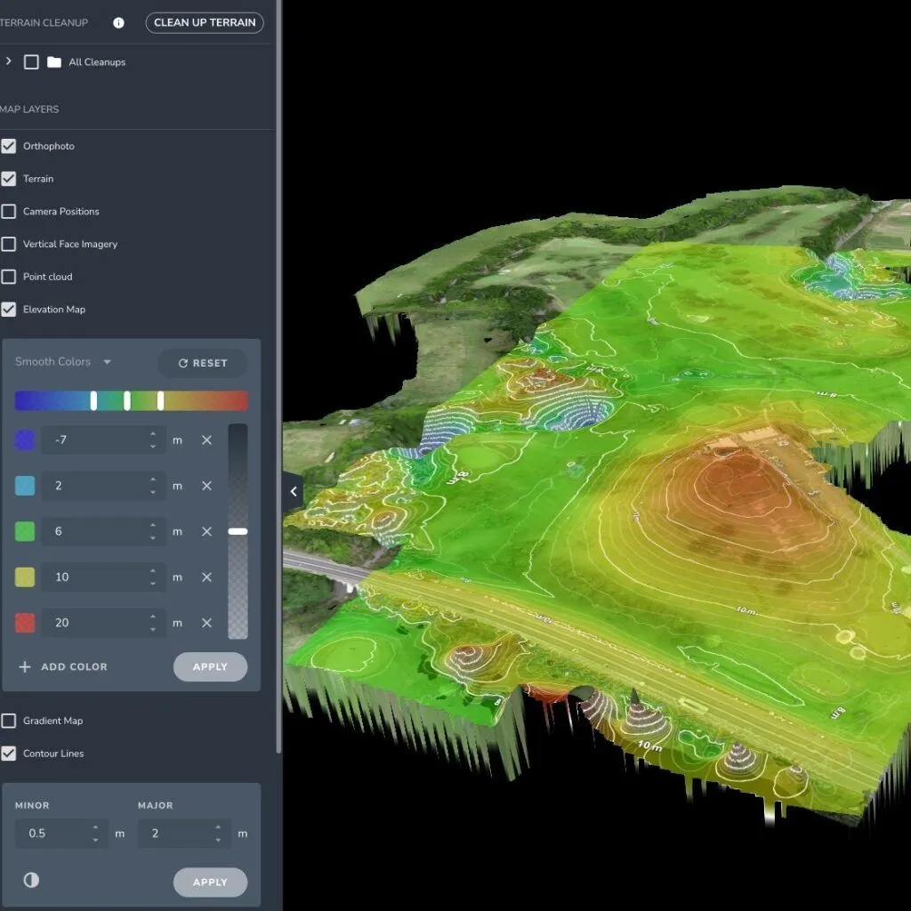
Drone Mapping & Surveying
✓ Topographic mapping
✓ Land surveying
✓ 3D modeling and photogrammetry
✓ Construction site monitoring
📐 Types of Drone Mapping & Surveying Services
- Topographic Mapping
- Contour lines and elevation data
- Site grading and earthworks planning
- Digital Terrain Models (DTM) and Digital Surface Models (DSM)
- Orthomosaic Mapping
- High-res stitched images of large areas
- Accurate, geo-referenced aerial maps
- Useful for agriculture, construction, and land planning
- 3D Modeling & Photogrammetry
- Realistic 3D reconstructions of terrain or structures
- Used for site visualization, inspections, or asset management
- Point cloud generation for CAD/GIS use
- Volumetric Analysis
- Measure stockpiles, earthworks, and excavation volumes
- Track changes over time
- Helps with inventory management in mining, construction, etc.
- Land & Property Surveys
- Boundary outlines (when coordinated with licensed surveyors)
- Land development and site planning support
- Plot division and layout visualization
- Infrastructure Monitoring
- Road, railway, and pipeline route surveys
- Bridge and structure deformation analysis
- Transmission line corridor mapping
🧠 Industries That Use Drone Mapping
- Construction & Civil Engineering
Progress tracking, earthworks planning, and as-built models. - Agriculture
Field boundary mapping, drainage analysis, and crop planning. - Mining & Quarrying
Mine planning, volumetric analysis, and safety assessments. - Environmental & Land Management
Wetland mapping, erosion tracking, wildlife habitat assessment. - Utilities & Energy
Site planning for solar/wind farms, line inspections, vegetation management. - Urban Planning & Development
Land use mapping, city planning, zoning analysis.
⚙️ Technology & Tools Used
- Cameras:
High-res RGB for visual mapping; multispectral for plant health; thermal for heat mapping. - LiDAR (Light Detection and Ranging):
For penetrating vegetation and achieving cm-level accuracy in elevation and terrain mapping. - RTK/PPK GPS:
Real-Time Kinematics or Post-Processed Kinematics for highly accurate georeferencing. - Software:
- DroneDeploy, Pix4D, Agisoft Metashape (mapping & modeling)
- ArcGIS, QGIS (GIS analysis)
- AutoCAD, Civil 3D (engineering integration)
✅ Benefits Over Traditional Surveying
- Faster data collection (cover large areas in hours)
- Access to hard-to-reach or dangerous terrain
- Increased frequency of site surveys (for tracking changes)
- Lower labor costs
- Highly visual and shareable deliverables
📋 Requirements & Considerations
- Regulatory Compliance: FAA Part 107 (US), airspace authorizations
- Accuracy Tolerance: Match the right drone and tools to the project’s required precision
- Ground Control Points (GCPs): May be needed for survey-grade accuracy
- Coordination with Surveyors/Engineers: Especially when legal boundaries are involved
🏗️ Construction & Infrastructure
Drone services for Construction & Infrastructure are booming — we can bring major efficiency, safety, and cost-saving benefits across every phase of a project, from pre-construction surveys to post-completion documentation.

Drone Mapping & Surveying
✓ Site inspection and progress tracking
✓ Volume measurements
✓ BIM integration
✓ Safety inspections
📊 Core Services
- Site Surveys & Pre-Construction Planning
- Topographic surveys for elevation, slope, and grading analysis
- Orthomosaic mapping for base layers in site design
- 3D terrain modeling for planning earthworks and drainage
- Volume measurements for cut-and-fill analysis
- Construction Progress Monitoring
- Weekly/monthly aerial captures for visual updates
- Compare current status vs. BIM/CAD plans
- Identify delays, missing materials, or layout errors early
- Cloud-based platforms allow stakeholders to remotely inspect sites
- Stockpile & Material Volume Calculations
- Quickly and accurately measure materials like gravel, sand, or soil
- Track changes over time for reporting and inventory management
- As-Built Documentation
- High-resolution, geo-referenced imagery of completed work
- Create “as-built” models and verify installation against plans
- Useful for handover packages and future maintenance
- Inspection of Hard-to-Reach Structures
- Bridges, rooftops, towers, cranes, scaffolding
- Reduce risk and time compared to manual inspections
- Identify issues like cracks, rust, water damage, or misalignments
- Marketing & Investor Updates
- Timelapse videos or progress reels for developers, stakeholders, and clients
- Professional photography for brochures, websites, or social media
🔧 Tech & Tools Used
- RTK/PPK drones: For sub-inch level survey accuracy
- 360° cameras & FPV drones: For immersive site walkthroughs
- LiDAR-equipped drones: To capture accurate terrain in vegetated or complex areas
- Thermal cameras: To detect leaks, insulation issues, or electrical faults
🛠️ Typical Deliverables
- Orthomosaic maps (2D)
- Digital Elevation Models (DEM), DSMs, and DTMs
- 3D mesh models and point clouds
- Volume reports and CAD integrations
- Annotated inspection images
- Progress dashboards and timelapse videos
🧠 Benefits to Construction Firms
- Faster surveys: Cover large sites in a few hours vs. days
- Real-time visibility: For PMs, investors, and stakeholders
- Fewer site visits: Use virtual inspections and remote project oversight
- Improved accuracy: Minimize rework due to early detection
- Better safety: Reduce need for scaffolding, climbing, or entering unsafe zones
🏗️ Who Uses These Services?
- General contractors
- Civil engineers
- Surveying and land development firms
- Architects and planners
- Real estate developers
- Municipalities and DOTs (Departments of Transportation)
📋 Compliance & Requirements
- FAA Part 107 certification (U.S.) or equivalent in other countries
- Safety protocols and flight planning (especially in urban/congested areas)
- Coordination with site managers to avoid disruption
- Insurance for commercial operations